What's in the Box:
- Dakota 20
- Trekmap Italy on microSD
- Lanyard
- USB cable
- Manuals
Outdoor navigation meets touchscreen simplicity in Dakota 20. This rugged, palm-sized navigator combines touchscreen navigation, high-sensitivity GPS with HotFix® satellite prediction, barometric altimeter, 3-axis electronic compass and microSD™ card slot in one affordable, power-packed punch.
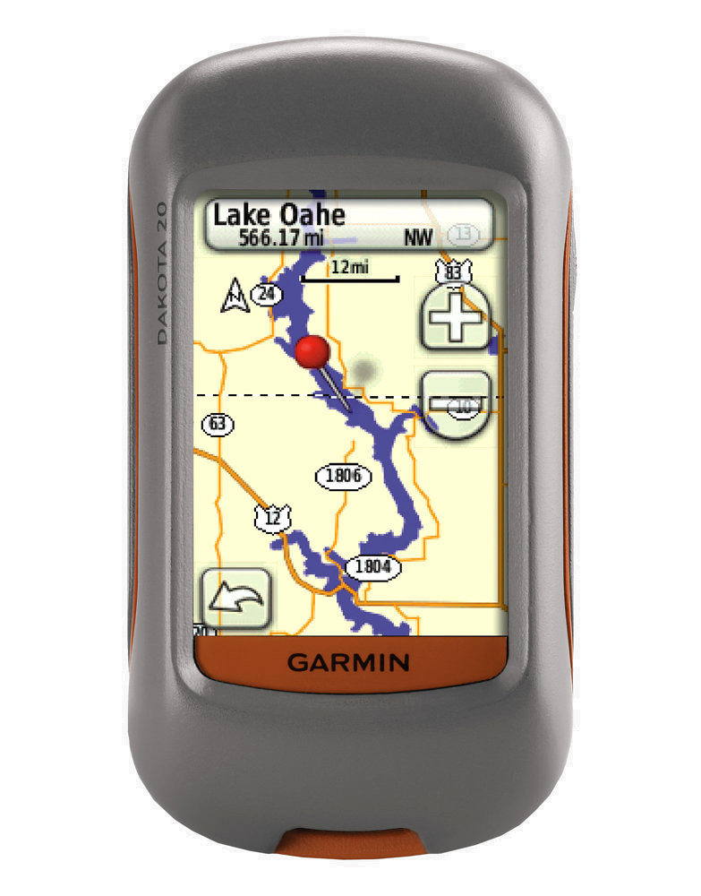
Touch and Go
Dakota 20 makes outdoor navigation effortless with a tough, sunlight-readable, 6.6 cm (2.6 in) colour touchscreen display. The interface is easy to use, so you’ll spend more time enjoying the outdoors and less time searching for information. Both durable and waterproof, Dakota 20 is built to withstand the elements; bumps, dust, dirt and water are no match for this rugged navigator.
Get Your Bearings
Dakota 20 has a built-in 3-axis electronic compass, which shows where you're heading even when you’re standing still or not holding the device level. Its barometric altimeter tracks changes in pressure to pinpoint your precise altitude, and you even can use it to plot barometric pressure over time, which can help you keep an eye on changing weather conditions. And with its high-sensitivity, WAAS-enabled GPS receiver with HotFix satellite prediction, Dakota 20 locates your position quickly and precisely and maintains its GPS location even in heavy cover and deep canyons.
Find Fun
Get into paperless geocaching with Dakota 20 by quickly downloading up to 2,000 caches with information such as location, terrain, difficulty, hints and description — no more paper print outs and manually entered coordinates! Visit our geocaching pages for more information.
Explore the Terrain
Dakota 20 comes with a built-in worldwide basemap, so you can navigate anywhere with ease. Adding more maps is easy with Garmin's wide array of detailed topographic, marine and road maps, available on microSD card.
Share Wirelessly
With Dakota 20 you can share your waypoints, tracks, routes and geocaches wirelessly with other compatible Dakota, Foretrex®, Oregon® and Colorado® users. Now you can send your favorite route or geocache location to a friend easily. Just touch "send" to transfer your information to similar devices.
Physical & Performance:
Unit dimensions, WxHxD: 2.2" x 3.9" x 1.3" (5.5 x 10 x 3.3 cm)
Display size, WxH: 1.43" x 2.15" (3.6 x 5.5 cm); 2.6" diag (6.6 cm)
Display resolution, WxH: 160 x 240 pixels
Display type: Transflective colour TFT touchscreen
Weight: 5.25 oz (148.8 g) with batteries
Battery: 2 AA batteries (not included); NiMH or Lithium recommended
Battery life: 20 hours
Waterproof: yes (IPX7)
Floats: no
High-sensitivity receiver: yes
Interface: USB
Maps & Memory:
Basemap: yes
Preloaded maps: no
Ability to add maps: yes
Built-in memory: 850 MB
Accepts data cards: microSD™ card (included: Trekmap Italia)
Waypoints/favorites/locations: 1000
Routes: 50
Track log: 10,000 points, 200 saved tracks
Features & Benefits:
Automatic routing (turn by turn routing on roads): yes (with optional mapping for detailed roads)
Electronic compass: yes (tilt-compensated, 3-axis)
Touchscreen: yes
Barometric altimeter: yes
Camera: no
Geocaching-friendly: yes (paperless)
Custom maps compatible: yes
Photo navigation (navigate to geotagged photos): no
Outdoor GPS games: no
Hunt/fish calendar: yes
Sun and moon information: yes
Tide tables: no
Area calculation: yes
Custom POIs (ability to add additional points of interest): yes
Unit-to-unit transfer (shares data wirelessly with similar units): yes
Picture viewer: no
Garmin Connect™ compatible (online community where you analyze, categorize and share data): yes
Trekmap Italy V3 Pro
Let us be your outdoor guide to paths, trails, lakes, mountains and more in Italy. A must for outdoor enthusiasts, this topographic product includes more than 12,000 km of trails compliant with our new ActiveRouting feature.
Offers digital topographic vector maps on microSD™/SD™
Shows dense contour lines and Digital Elevation Model (DEM) data at 20 m intervals
Displays routable biking/hiking routes and 113,000 km of trail/bicycle paths in selected zones and the national road network as well as more than 12,000 km of trails fully compliant with the new ActiveRouting feature¹
Includes searchable business/touristic/outdoor/recreational points of interest, geographic places, mountain ranges, city points and many other recreational POIs
Shows activity specific display with highlights on suggested routes
Includes preloaded BaseCamp™ software that lets you plan trips on your computer and transfer routes and waypoints from your computer to your compatible device.