Model:
Garmin Oregon 450 + microSD TrekMap ItaliaCode:
020-00089-00What's in the box
- Oregon 450
- Carabiner clip
- USB cable
- Manual
- microSD TrekMap Italia
With Oregon 450 you can really get in touch with nature. This next-generation handheld features a rugged, sunlight-readable, touchscreen along with a built-in basemap with shaded relief, a high-sensitivity receiver, barometric altimeter, 3-axis electronic compass, microSD™ card slot, picture viewer and more. Even exchange tracks, waypoints, routes and geocaches wirelessly between similar units.
Touch and Go
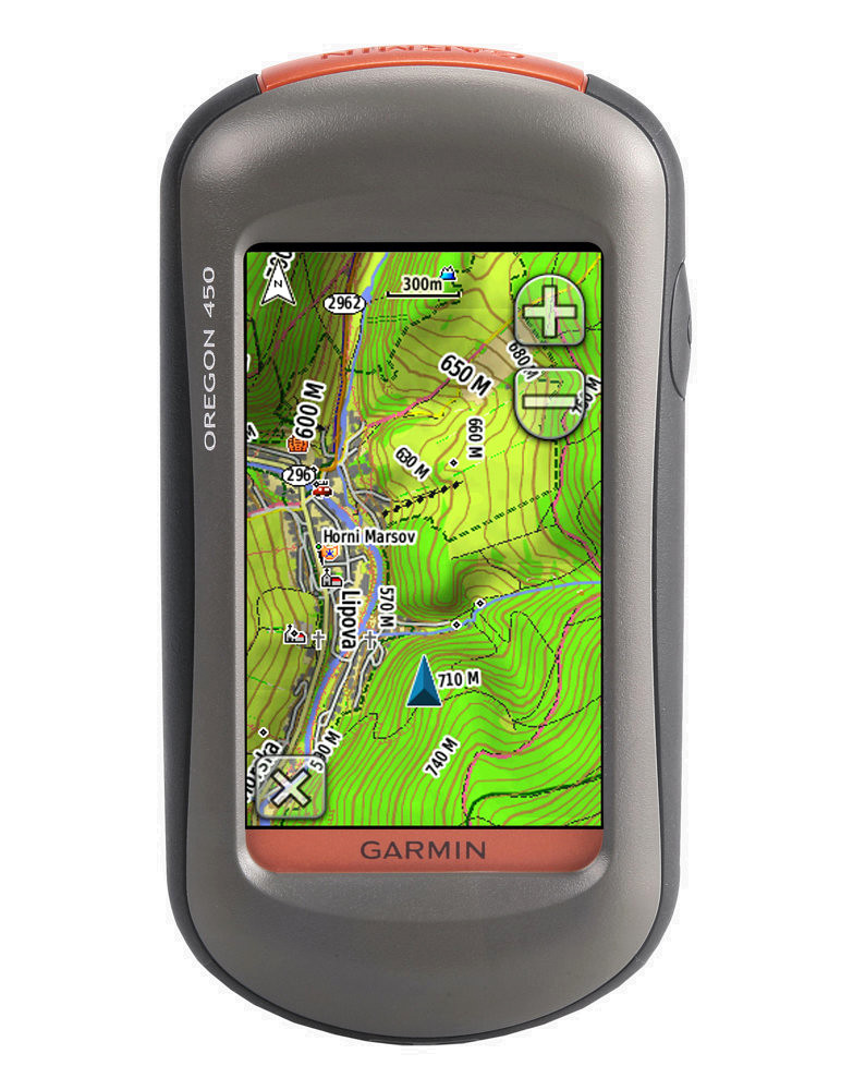
Oregon 450 leads the way with a tough, 3-inch diagonal, sunlight-readable, colour, touchscreen display that offers crystal-clear enhanced colours and high-resolution images. Its easy-to-use interface means you’ll spend more time enjoying the outdoors and less time searching for information. With user-selectable dashboards, you can customise the appearance of your display. Both durable and waterproof, Oregon 450 is built to withstand the elements. Bumps, dust, dirt, humidity and water are no match for this rugged navigator.
Explore More
Oregon 450 comes with a built-in worldwide basemap with shaded contours. Simply touch the colour screen to navigate. Its digital elevation maps show you shaded contours at higher zoom levels, giving you a big picture of the surrounding terrain.
Share Wirelessly
With Oregon 450 you can share your waypoints, tracks, routes and geocaches wirelessly other compatible Oregon, Colorado and Dakota users. Now you can send your favourite hike to your friend to enjoy or the location of a cache to find. Sharing data is easy. Just touch “send” to transfer your information to similar units.
Find Fun
Oregon 450 supports Opencaching.com GPX files for downloading geocaches and details straight to your unit. By going paperless, you're not only helping the environment but also improving efficiency. Oregon stores and displays key information, including location, terrain, difficulty, hints and descriptions, which means no more manual entering of coordinates or soggy paper print outs! Simply upload the GPX file to your unit and start hunting for caches. Show off photos of your excursions with Oregon’s picture viewer. Slim and lightweight, Oregon is the perfect companion for all your outdoor pursuits.
Get Your Bearings
Oregon 450 has a built-in 3-axis tilt-compensated electronic compass, which shows your heading even when you’re standing still, without holding it level. Its barometric altimeter tracks changes in pressure to pinpoint your precise altitude, and you can even use it to plot barometric pressure over time, which can help you keep an eye on changing weather conditions. See changes in your elevation ahead of you and where you've been with enhanced track navigation. With its high-sensitivity, WAAS-enabled GPS receiver and HotFix™ satellite prediction, Oregon 450 locates your position quickly and precisely and maintains its GPS location even in heavy tree cover and deep valleys.
Add Maps
Conveniently plug in optional preloaded microSD cards for all your outdoor activities on land or water (see maps tab for compatible maps). Just insert a MapSource® card with detailed street maps, and Oregon provides turn-by-turn directions to your destination. Add selected topographic maps to take advantage of Oregon’s 3D map view which gives you a better perspective of your elevation. With BlueChart® g2 , you’ll get everything you need for a great day on the water including depth contours, navaids and harbours. The card slot is located inside the waterproof battery compartment, so you don't have to worry about getting it wet.
Get Connected
You've been busy exploring and now you want to store and analyse your activities. With a simple connection to your computer and to the Internet, you can get a detailed analysis of your activities and send tracks to your outdoor device using Garmin Connect™. This one-stop site offers an activity table and allows you to view your activities on a map using Google™ Earth. Explore other routes uploaded by millions of Garmin Connect users and share your experiences on Twitter® and Facebook®. Getting started is easy, so get out there, explore, and share.
Physical & Performance
Unit dimensions, WxHxD: 2.3" x 4.5" x 1.4" (5.8 x 11.4 x 3.5 cm)
Display size, WxH: 1.53"W x 2.55"H (3.8 x 6.3 cm); 3" diag (7.6 cm)
Display resolution, WxH: 240 x 400 pixels
Display type: Transflective colour TFT touchscreen
Weight: 6.8 oz (192.7 g) with batteries
Battery: 2 AA batteries (not included); NiMH or Lithium recommended
Battery life: 16 hours
Waterproof: yes (IPX7)
Floats: no
High-sensitivity receiver: yes
Interface: high-speed USB and NMEA 0183 compatible
Maps & Memory
Basemap: yes
Preloaded maps: no
Ability to add maps: yes
Built-in memory: 850 MB
Accepts data cards: microSD™ card (included: TrekMap Italia)
Waypoints/favorites/locations: 2000
Routes: 200
Track log: 10,000 points, 200 saved tracks
Features & Benefits
Automatic routing (turn by turn routing on roads): yes (with optional mapping for detailed roads)
Electronic compass: yes (tilt-compensated, 3-axis)
Touchscreen: yes
Barometric altimeter: yes
Camera: no
Geocaching-friendly: yes (paperless)
Custom maps compatible: yes
Photo navigation (navigate to geotagged photos): yes
Outdoor GPS games: yes (Wherigo only)
Hunt/fish calendar: yes
Sun and moon information: yes
Tide tables: Yes (with optional Bluechart)
Area calculation: yes
Custom POIs (ability to add additional points of interest): yes
Unit-to-unit transfer (shares data wirelessly with similar units): yes
Picture viewer: yes
Garmin Connect™ compatible (online community where you analyze, categorize and share data): yes
Trekmap Italy V3 Pro
Let us be your outdoor guide to paths, trails, lakes, mountains and more in Italy. A must for outdoor enthusiasts, this topographic product includes more than 12,000 km of trails compliant with our new ActiveRouting feature.
Offers digital topographic vector maps on microSD™/SD™
Shows dense contour lines and Digital Elevation Model (DEM) data at 20 m intervals
Displays routable biking/hiking routes and 113,000 km of trail/bicycle paths in selected zones and the national road network as well as more than 12,000 km of trails fully compliant with the new ActiveRouting feature¹
Includes searchable business/touristic/outdoor/recreational points of interest, geographic places, mountain ranges, city points and many other recreational POIs
Shows activity specific display with highlights on suggested routes
Includes preloaded BaseCamp™ software that lets you plan trips on your computer and transfer routes and waypoints from your computer to your compatible device.